
Hurricane Forecasting in 2025
Air Date: Week of June 6, 2025
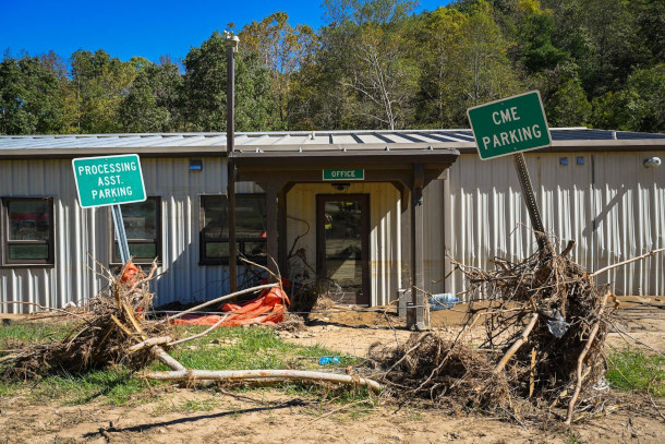
The 2025 Atlantic hurricane season is predicted to have slightly above average activity. The aftermath of 2024 Hurricane Helene in North Carolina is pictured above. (Photo: NCDOTcommunications, Wikimedia Commons, CC BY 2.0)
The 2025 hurricane season is underway, and experts say the U.S. is likely to see higher than average activity. The past couple of years, extremely warm water in the Gulf of Mexico helped storms rapidly intensify into major hurricanes. Ryan Truchelut of consulting firm WeatherTiger talks with Host Aynsley O’Neill about what’s in store this season and how cuts to federal weather monitoring and hurricane modeling could leave the U.S. underprepared for strengthening storms.
Transcript
DOERING: From PRX and the Jennifer and Ted Stanley Studios at the University of Massachusetts, Boston, this is Living on Earth. I’m Jenni Doering.
O’NEILL: And I’m Aynsley O’Neill.
In 2024, five major hurricanes made landfall in the continental United States, wreaking havoc as far inland as Asheville, North Carolina. At least 250 people died because of Hurricane Helene, making it the deadliest hurricane to strike the U.S. since Katrina in 2005. Now, the 2025 hurricane season is underway, and experts say we’re likely to see slightly higher than average activity. One of these experts is Ryan Truchelut, Co-founder, President, and Chief Meteorologist for the consulting firm WeatherTiger, and he joins us now. Welcome back to Living on Earth, Ryan!
TRUCHELUT: Thank you for the invitation, and happy hurricane season.
O'NEILL: Happy hurricane season. And I guess the question is, how much of a happy hurricane season will it be? I saw we might be expecting a little higher than normal activity. What would a season like that look like?
TRUCHELUT: Well, as a seasonal forecaster, I always try to stay very focused on landfall risks, because we don't so much care about how much hurricane activity happens out in the open ocean. What we care about are the human and economic impacts of these storms, which are very significant. We've done almost a trillion dollars worth of economic damage in the continental United States just in the last 15 years from landfalling hurricanes. In a typical Atlantic hurricane season, the United States averages one to two hurricane impacts per season. Major hurricanes, those are category threes, fours and fives, you get one of those on average about every other hurricane season. So there's about a 50-50 chance in an average hurricane season, if you're going to get a category three or above. In this hurricane season, those odds being tilted in a slightly more active, slightly riskier direction than normal, puts us in a ballpark of probably about a 50% chance of either two or three US hurricane landfalls in the upcoming season, as opposed to that one to two typical number. And then, as opposed to the 50% average chance of a major hurricane landfall, we have maybe a 55 or a 60% chance of a major hurricane landfall somewhere in the continental US in the upcoming season. Now, just because I know that listeners are probably thinking about it, there's only about a 5% chance that the 2025 hurricane season would equal those five US hurricane landfalls that we saw in 2024. So we're not looking more than likely at another year like 2024, but we are looking at a year that's likely to have some significant impacts on the continental United States.
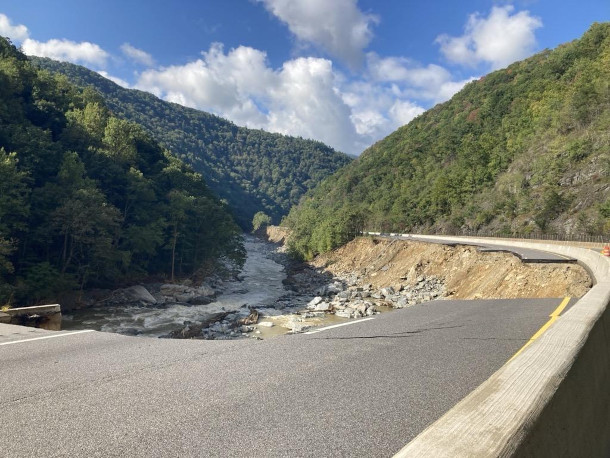
Hurricane Helene reached as far inland as the mountains of North Carolina in 2024, washing out numerous roads and bridges. Truchelut says there is only around a 5% chance that the 2025 Atlantic hurricane season will equal the five major hurricane landfalls seen in 2024. (Photo: NCDOTcommunications, Wikimedia Commons, CC BY 2.0)
O'NEILL: And Ryan, to what extent is climate change and increasing global temperatures, how are those affecting what we're likely to see in 2025 and beyond?
TRUCHELUT: Sure. Well, I think that there's definitely a climate change fingerprint on the sea surface temperatures that we saw in 2023 and 2024 because they were so far beyond other warm years in the historical record. You simply would not be able to get sea surface temperatures that warm over that large an area without there being some unnatural influence of increased, basically, radiation capture, because we're changing the chemical composition of the atmosphere, we're changing the concentration of greenhouse gasses. You know, overall, this is a tricky question, because there hasn't been a overall trend towards more hurricanes, tropical cyclones worldwide in the past 30 or 40 years in the period of the historical record we can trust. It does seem like there's been more hurricane activity in the Atlantic, specifically. For individual storms, you can definitely say that there is some influence going on when you look in the aggregate.
O'NEILL: So while there may not be more hurricanes per se, you know, to what extent is climate change impacting, you know, the strength of these storms?
TRUCHELUT: Climate change is definitely having an influence on the human impacts of individual storms. And I think a really evocative example of this is Hurricane Helene last year, because one of the things that scientists have high confidence in saying is a change in how hurricanes are developing and how hurricanes are moving and the impacts that they're having from climate change is in terms of precipitation. We know that hurricanes are producing more precipitation because the atmosphere is warming, warmer air can hold more water vapor and transport it inland. So for a hurricane like Helene, the fact that it was moving over waters that were two or three degrees warmer than they would normally be in late September in the Gulf, and the fact that it was moving 30 miles an hour when it came inland, allowed it to transport an enormous amount of moisture, far more than any other hurricane in the historical record, north across the southeastern United States and into the mountains of North Carolina, and resulted in an unprecedented devastation across that region. So we have always had hurricanes in the Gulf, and we always will have hurricanes in the Gulf, but they're a little bit stronger by virtue of climate change, and they're creating more precipitation and thus more human impacts because of climate change.
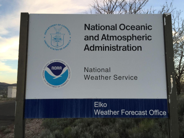
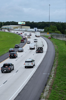
Cuts to government agencies like the National Oceanic and Atmospheric Administration and the National Weather Service will put a strain on resources for storm readiness in 2025, according to Truchelut. (Photo: Famartin, CC BY-SA 4.0, Wikimedia Commons)
O'NEILL: Now Ryan, this prediction for a slightly higher activity hurricane season, it's coming at a time when the Trump administration is cutting staff and programs at the National Oceanic and Atmospheric Administration, or NOAA, the Federal Emergency Management Agency, or FEMA, and the National Weather Service, NWS. So how will moves like this affect the country's storm readiness?
TRUCHELUT: Well, in several different ways. For one, the job cuts at NOAA and the National Weather Service are stretching this organization very, very thin. So National Weather Service has a network of over 120 field offices across the United States where forecasters are on the ground in communities. Every one of those offices operates, 24/7, 365. They are on call around the clock, providing both routine and emergency weather forecasting. And unfortunately, because there's been so many job losses in many of these offices, several of them are no longer able to be staffed 24/7, which is a real break with the tradition of the National Weather Service. They simply don't have the people in place to be able to do their job. And a lot of these offices that are lacking key leadership are along the Gulf Coast. They're places like Houston, Tampa Bay. These are places that are vulnerable, that have been hard hit just within the past decade. So we don't have the staff in place to communicate the threats to the public in the way that we typically do. By virtue of cutting staff, we've also reduced the number of weather balloon launches that are occurring across the United States. The data that goes into a model is so crucial for getting good forecasts out of it. So if you don't have a good initial snapshot, initial picture of what's going on in the atmosphere, even the very best atmospheric model is not going to be very useful. So by cutting down on our key observational networks, we're hobbling our ability to make accurate forecasts. We've also made cuts to our research divisions that focus on things like developing better hurricane models, cutting our hurricane hunter forces and personnel. So we're vulnerable, and I can only hope that we won't be tested beyond our breaking point in the upcoming season.
O'NEILL: Well, so Ryan, with these impacts at the federal level, what tools do weather forecasters have at their disposal that they can still use to help communities in 2025?
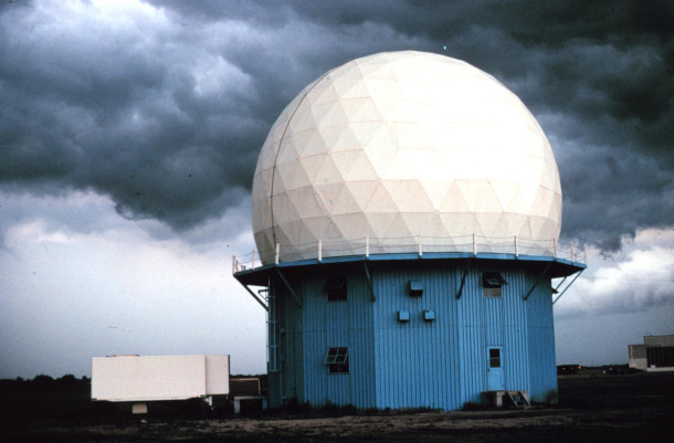
The National Severe Storms Laboratory’s first Doppler Weather Radar located in Norman, Oklahoma. Private forecasters are dependent on these kinds of public resources. (Photo: OAR/ERL/National Severe Storms Laboratory (NSSL)., Wikimedia Commons, Wikimedia Commons, public domain)
TRUCHELUT: Sure. Well, you know, I want to emphasize that I'm a private forecaster. I run a private company. I'm not affiliated with the government, but like every forecaster, the tools that I'm using to do my job and give, you know, basically, more specific information to specialized clients, everything I'm doing is predicated on data and resources from the public sector. I'm totally dependent on NOAA hurricane modeling. I'm totally dependent on radar networks, on satellite networks, observations, historical data sets that are all maintained at no cost and made open source, made available directly to the public by NOAA and the National Weather Service. So you know, these things that we have, we've built them over a long period of time. You know, Rome wasn't built in a day, and it can't be taken apart in a day, either. So you know these tools, they are still available for now, but we certainly need to appreciate that these are all institutions that require maintenance. They require staffing. They require public resources to be invested in them, because all that investment has a huge payoff for society at large. It pays for itself so many times over to invest in public safety and invest in disaster resilience and disaster response. And I know hurricane forecasters in both the public and private sector, we will do our very best to provide the public the best information that we can this year, you know, no matter what, but please don't take away the tools that we use to be able to make those forecasts.
Our guest Ryan Truchelut advises listeners to have an emergency evacuation plan in place far before storms make landfall. (Photo: Andrew Heneen, Wikimedia Commons, CC BY 4.0)
O'NEILL: Now for those of us out here who are in areas that might be vulnerable to hurricanes, what actions should we be taking? What actions are in our control in order to head into this 2025 season well prepared?
TRUCHELUT: The best single piece of advice that I can give someone who is in a hurricane threat area, which is basically all of the East Coast and southern coast of the United States, you need to be aware of what you would do if you were called upon to evacuate. So you don't want to be coming up with a plan when you are scared, there's a storm out on the water, and you don't know what you're going to do. You're not going to make the best decision for yourself or your family. So think about it ahead of time. Have an evacuation plan. Have an emergency kit that has several days worth of food, water, cash, medication, basics that you need to keep yourself safe.
O'NEILL: Now, Ryan, let's step back for a second. Where are we in this current climate moment as a society, and to what extent are the threat of more intense storms or flooding, or even things like wildfires, all fueled by climate disruption, to what extent are those things changing how we feel and how we act?
TRUCHELUT: Well, I think that the last 10 years, as a resident of the Gulf Coast, we've had an unprecedented run of major hurricane landfalls here. We've had 10 major hurricane landfalls since 2017. That's the most that there have ever been in a 10-year period here. Cumulatively, those storms have done over $700 billion worth of damage. So I think there's a sense here, even amongst people who aren't necessarily predisposed to believe, quote, in climate change, that the present is not like the past. You know, I go out and speak to all sorts of audiences, you know, out in, I'm an agricultural meteorologist, too. So I talk to farmers, I talk to people who fish, who live on the Gulf Coast, and they know that the water temperature in the eastern Gulf of Mexico should not be 88 degrees late in September. It's not normal. These are people who have gone out and they've lived in nature. They're familiar with the natural environment, and they know when things are different. Farmers know when they are planting their crops. They have good records of this going back decades and decades, and they're planting their crops earlier and earlier because the frost dates keep moving earlier in spring. So I guess what I would say is, I think we're at the place where experience is the best teacher.
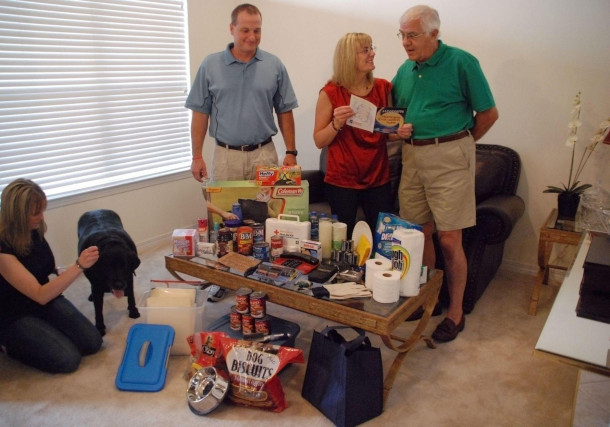
Part of an evacuation plan can include creating an emergency kit that includes food, water, medication, and other essential items. (Photo: Jennifer Smits, Wikimedia Commons, public domain)
O'NEILL: Ryan, it seems as though it's not really even a matter of living in a new climate normal at this point. The situation is constantly changing. How have you dealt with that reality over the course of your career?

Ryan Truchelut is co-founder, president, and chief meteorologist for WeatherTiger, a group of professionals dedicated to advancing the science of forecasting. (Photo: Courtesy of Ryan Truchelut)
TRUCHELUT: So it's been a bit of a challenge to wrap my mind around this, because I'm a hurricane climatologist. When I went to graduate school, all my dissertation research was going back into hurricane history, learning what we can from it. So I have a very clear sense of what history teaches us about hurricane activity and sort of what the bounds are. And as a forecaster, as someone who actually is down in the trenches writing forecasts, you know, advising people about how to respond to the storms of the past 10 years, I have been floored over and over again by things that simply have no reference point in the historical record happening. And as a forecaster, it feels almost irresponsible to forecast something that's never happened before. It makes me deeply uncomfortable, as a scientist, to be going outside that realm of what's happened in the past. Unfortunately, there are simply more things in the mix as a possibility in the year 2025 than there were in 1870 or 1900. The odds have shifted towards increasing probability of a storm intensifying rapidly in the last 24 hours before landfall, increasing probability of certain precipitation thresholds being reached in cities along the Gulf Coast of heavy rainfall coming from tropical cyclones. So it's been an adjustment, and I would say that as these extraordinary and rare events have happened with increasing frequency, I'm more comfortable at making forecasts now for something way outside the bounds of the historical realm, because it simply happened so much in the past 10 years that I'd be foolish not to be a little more willing to go further out on a limb.
O'NEILL: Ryan Truchelut is Chief Meteorologist at WeatherTiger in Tallahassee, Florida. Thank you so much for taking the time with us today, Ryan.
TRUCHELUT: Take care and stay safe this season.
Links
Living on Earth wants to hear from you!
Living on Earth
62 Calef Highway, Suite 212
Lee, NH 03861
Telephone: 617-287-4121
E-mail: comments@loe.org
Newsletter [Click here]
Donate to Living on Earth!
Living on Earth is an independent media program and relies entirely on contributions from listeners and institutions supporting public service. Please donate now to preserve an independent environmental voice.
NewsletterLiving on Earth offers a weekly delivery of the show's rundown to your mailbox. Sign up for our newsletter today!
![]() Sailors For The Sea: Be the change you want to sea.
Sailors For The Sea: Be the change you want to sea.
 The Grantham Foundation for the Protection of the Environment: Committed to protecting and improving the health of the global environment.
 Contribute to Living on Earth and receive, as our gift to you, an archival print of one of Mark Seth Lender's extraordinary wildlife photographs. Follow the link to see Mark's current collection of photographs.
 Buy a signed copy of Mark Seth Lender's book Smeagull the Seagull & support Living on Earth
© Copyright World Media Foundation. All Rights Reserved
Home | Contact | RSS | Donate | Newsletter