
June 16, 2006
Air Date: June 16, 2006
FULL SHOW
SEGMENTS
New Nukes for North America
View the page for this story
Ontario, Canada plans to build two new nuclear reactors in the province to meet increasing demand for electricity.. At the same time, the government has delayed closing its existing coal plants as promised. Host Steve Curwood talks with Bob Carty, of the Canadian Broadcasting Corporation, about the controversial plan. (06:00)
Row Over Roadless Area
/ Ley GarnettView the page for this story
An area of wild, roadless and burned forest raises every current hot button issue in forestry today: Should burned areas be left to lie, or logged? Should loggers be allowed in forests where no vehicle has traveled? And who decides, the federal government, or the state of Oregon? Ley Garnett of Oregon Public Broadcasting reports. (06:20)
New Marching Orders for the Army Corps of Engineers
/ Jeff YoungView the page for this story
In the wake of Hurricane Katrina there's a move to reform the Army Corps of Engineers. Critics say the Corps needs to better plans and design its massive water control projects. But Living on Earth's Washington correspondent Jeff Young tells us that would require big changes in Congress, too. (05:40)
Lake Okeechobee At Risk
View the page for this story
Lake Okeechobee, the second largest lake in the contiguous US, has been called the “Liquid Heart” of Florida, and a 143-mile dike keeps it from spilling over. But new maps from the Army Corps show weaknesses in the walls that could mean disaster for the communities around the lake if a massive hurricane were to breach the dike. Host Steve Curwood talks with Associated Press reporter Brian Skoloff about why the Corps is keeping the maps under wraps. (07:15)
Shelter from the Storm
View the page for this story
Brad Webb of Tulsa, Oklahoma, offers shelter from the storm with his industry-tested product: The Storm Safe Room. (04:40)
Emerging Science Note/Backs to the Future
/ Tobin HackView the page for this story
Living on Earth's Tobin Hack reports on a culture where gestures to the past and the future are reversed. (02:10)
Remaking the Los Angeles River
/ Ilsa SetziolView the page for this story
Straightened, lined with concrete, filled with treated sewage, is there still a river in the Los Angeles River? Angelenos are saying yes, and demanding that planners and engineers go to lengths, even great lengths, to bring back a stream Los Angeles can call its own. Ilsa Setziol reports. (15:25)
Show Credits and Funders
Show Transcript
HOST: Steve Curwood
GUESTS: Brian Skoloff, Brad Webb
REPORTERS: Bob Carty, Ley Garnet, Jeff Young, Ilsa Setziol
SCIENCE NOTE: Tobin Hack
[THEME MUSIC]
CURWOOD: From NPR, this is Living on Earth.
[THEME MUSIC]
CURWOOD: I’m Steve Curwood. The Canadian province of Ontario says it needs more electricity, and can’t do without two more of its CANDU nuclear reactors.
DUNCAN: Listen, if I had my druthers, it’d be 100 percent hydroelectric. Nuclear power has an important role to play, we want to balance that with other sources of electricity, moving forward.
CURWOOD: But critics claim conservation and alternative energy sources make nuclear power in Canada unnecessary:
STEWART: It’s a technology that gotten us into the problem we’re in right now, so you shouldn’t be looking at it as a way to dig yourself out.
CURWOOD: And fears Florida’s lake Okeechobee could burst through it’s dike:
SKOLOFF: If the lake were at 21 feet and a major hurricane were to come through today, a breach could occur on the south side. Flooding could extend about 32 miles south and remain inundated for 45 days as they repair the dike.
CURWOOD: This week on Living on Earth. Stick around.
[NPR NEWSCAST]
ANNOUNCER: Support for Living on Earth comes from the National Science Foundation and Stonyfield Farm.
New Nukes for North America

Darlington Station, in southern Ontario is the potential site for new nuclear reactors. (Photo courtesy of: Ontario Power Generation, Inc.)
CURWOOD: From the Jennifer and Ted Stanley Studios in Somerville, Massachusetts, this is Living on Earth. I’m Steve Curwood.
Nuclear power is set to make a major comeback in North America. The Bush administration recently pushed a plan through Congress that grants as much as 15 billion dollars in federal aid, to jumpstart nuclear power plant construction, in the United States. And now in Canada the provincial government of Ontario has just announced it will spend 40 billion dollars to upgrade old atomic power stations and build some new ones.
Joining me from Ottawa is Bob Carty. He’s a senior journalist with the Canadian Broadcasting Corporation. Hi Bob.
CARTY: Hi, Steve.
CURWOOD: So, Canada eventually stopped building nuclear power plants in the 90s after building a lot of them in the 60s. Why have you guys changed your minds?
CARTY: Well, a number of things happened since about 93, when the last power plant went up. It had huge cost overruns, you know, we’re still paying on our electricity bills for the debt of 30 billion dollars for that plant. So yes, as you say, nuclear was out of favor, but since then these things have happened: the economy boomed, demand for electricity increased, the population is growing.
At the same time, a previous conservative government cut conservation, so there were no gains happening there. So the current situation is you have a reliance upon nuclear, hydro and coal. And that’s grown, actually, in recent years because there’s been so many breakdowns at the CANDU nuclear reactors we have here – bursting pipes, radiation leaks and so on. Eight reactors had to be closed down to be repaired; four of them are still closed down.
And that meant generating more and more electricity with coal, which is very polluting, contributes about 25 percent of Ontario’s entire greenhouse gases, and doctors say actually perhaps kills about 1,500 people a year because of respiratory problems. So something had to be done to solve all those problems, and to keep the lights on. I don’t think any of this, though, you don’t see a mention, Steve, in any of the documentation of the government about this being motivated in any sense by Kyoto.
CURWOOD: So explain to me this Ontario plan financially. How much is the government going to spend on nuclear and how much on renewables and conservation?
CARTY: The government says this is a multi-year, 60 U.S. billion plan. Of that, a good chunk, 40 billion dollars, is going to build two new nuclear facilities and refurbish or repair four existing ones. And then they have another 20 billion dollars or so to invest in conservation, to develop more hydroelectricity, to stimulate solar, wind, biomass electricity production. It’s called a balanced plan by the minister of energy, Dwight Duncan, and here’s a little tape from him:
Darlington Station, in southern Ontario is the potential site for new nuclear reactors. (Photo courtesy of: Ontario Power Generation, Inc.)
CURWOOD: Now he seems to be holding his nose a bit there on the nuclear power, and likes hydro, so why doesn’t he just go that way?
CARTY: Well, it’s complicated. There’s only a certain amount of hydro resources left in Ontario. We have a long tradition in hydro-generation. The big rivers in the south – think of the St. Lawrence, you think of Niagara – they’re all dammed. There are rivers in the far north of Ontario, but this is a big province and you lose a lot of power just in transmission from the north to the south.
But one thing that’s really ironic is there could be a lot of hydro-generation on a sort of micro scale, you know, very small rivers. There could also be a reversal of a previous decision; earlier governments, conservative governments, concentrating so much on nuclear, shut down small river or medium size river dams. They took the generators out; too costly, they said, to maintain them. So critics say that, you know, you could get quite a bit of power by putting turbines back in those existing rivers.
CURWOOD: Now, how has the environmental community responded to this announcement?
CARTY: Well they say, first of all, that Ontario’s commitment to shutting down the coal generation of electricity is a bit in doubt now. Originally it was going to be shut down next year; now it’s put off at least two years, and who knows when there’ll be new power in hand. So they’re a bit concerned about that issue. But in terms of turning nuclear, the environmentalists say that all of Ontario’s future needs could in fact be met by conservation and alternative generation. They say, look, California’s done it. They’ve in conservation saved as much electricity as nuclear plants of Ontario generate.
Here’s Keith Stewart, Steve. Keith Stewart runs the climate change campaign at the World Wildlife Federation of Canada.
STEWART: This is about a 20 percent growth in nuclear power from what we have right now on line, and we actually are seeing that consumption will continue to grow, so it’s not a conservation plan. A conservation plan means you use less, not you use more, and an effective nuclear strategy right now would be to phase out what we have as they come to the end of their life because it’s a technology that has gotten us into the problem we’re in right now. So you shouldn’t be looking at it as a way to dig yourself out.
CURWOOD: Now Bob, with this expansion of nuclear, how’s Canada going to handle the nuclear waste?
CARTY: Well, we have about 30,000 tons of highly radioactive waste built up since the 60’s, Steve, and no disposal plan at all. In fact, a sort of satirical songwriter here says it’s like putting up an outhouse without digging a hole.
CURWOOD: (Laughs) Okay. But really, Bob, where is the waste right now then?
CARTY: It’s just sitting on site. It’s at the nuclear plants. It’s either in containers or sitting in heavy water tanks that are on the facility there, just waiting for a plan. There’ve been a lot of studies. They’ve dug into the Precambrian Shield rock of Ontario and Manitoba, they’ve looked at different technologies, but they haven’t made the investment, they haven’t made the decision, they’ve put it off I guess for future generations to pay the cost.
CURWOOD: Bob Carty’s a senior journalist with the national radio network of Canada, the Canadian Broadcasting Corporation. Thanks so much, Bob.
CARTY: You’re welcome, Steve.
Related links:
- Ontario Ministry of Energy
- Ontario Office of the Premier
Row Over Roadless Area
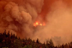
The Biscuit Forest Fire of 2002 destroyed nearly half a million acres in Oregon. (Credit: Photo courtesy of: USDA Southern Research Station)
CURWOOD: As the Clinton administration was leaving office it decreed that certain wild areas of national forests should remain free of roads. The Bush White House has since sought to roll back the roadless rules, saying, among other things, that local officials should have more control. Ironically, in Oregon, the Bush Administration is now insisting that a roadless area be opened up for logging, despite the objections of the state’s governor.
At issue is part of a half-million acres that burned in 2002 in the famous Biscuit Forest Fire. Conservationists say leaving the burned forest is the best way to regenerate the trees and the rare vegetation found there. But since the fire, timber companies have been trying to enter the area to cut damaged trees before they decay, and the Forest Service has now granted some limited access.
Oregon Public Broadcasting’s Ley Garnet has our story.
GARNET: For a low-key guy, Oregon Governor Ted Kulongoski is hopping mad. As he recalls it, the Bush administration told him and 49 other governors that if they wanted to preserve the roadless areas of federal forests in their states, they had to draw up a petition stating as much. The Governor is doing that. He also filed a lawsuit to protect the burned area, and he’s used the channels that come with the office of governor.
The Biscuit Forest Fire of 2002 destroyed half a million acres in Oregon. (Photo courtesy of: USDA Southern Research Station)
KULONGOSKI: I thought I had an understanding, and I thought the federal government’s position was, until all of the administrative procedures and all these legal issues get resolved, there would be a status quo. Obviously there’s been a change of heart. And I just think we should have the status quo until this is all resolved.
GARNETT: The fight over what should be done with land burned in the Biscuit Fire has been fierce.
[PUBLIC DEMONSTRATION SOUNDS: Public lands, not private profits!}
GARNETT: This demonstration in Portland is one of many in the last four years. More than 100 protestors have been arrested at the logging sites and several of them have gone to jail. One of them, George Sexton, is conservation director for the Klamath-Siskiyou Wildlands Center. He says logging the burned area is going to harm, not help, the forest recovery.
SEXTON: And so they’re only taking the biggest, best trees, which are extremely important for future soil, for holding together the steep slopes above salmon-bearing streams, and for wildlife habitat and recruitment. They need to be spending these types of resources going into the small diameter plantations that they’ve created throughout the landscape and providing sustainable jobs and doing real fire prevention instead of going in for one last old growth gold rush in the Matrix lands.
GARNETT: New and controversial research from Oregon State University seems to back up the idea of letting the burned forest lie. Graduate student Dan Donato studied the landscape left behind by the Biscuit burn and found that new trees were sprouting from the ashes. He got his paper published in the journal of Science, but he encountered some resistance from some, at his own university. Soon, he found himself testifying before a Congressional subcommittee convened in Medford, Oregon.
DONATO: We found substantial conifer establishment two and three years after the fire, and that seedlings were surviving multiple years. Mature trees distributed throughout the burn that had not been killed by the fire probably acted as seed sources, and this underscores the importance of surviving trees to forest regeneration.
GARNETT: Then Donato and his fellow researchers compared areas left alone with those that had been salvage logged.
DONATO: The regeneration we observed was reduced by 71 percent as a result of the salvage operations. This was due to soil disturbance and burial by woody materials.
GARNETT: But forestry is economics as much as science. Many people in this part of Oregon are just as passionate that salvage logging provides jobs and helps pay to replant the forest. Former Oregon state Republican Party chairman Kevin Mannix spoke at a rally in Medford outside the Forest Service office, while inside, timber sales were up for bidding.
MANNIX: I thank you for coming here today to show your support for our timber workers, for those involved in the timber industry, and for the fair, balanced and progressive policies that are now finally being implemented so we can get Oregonians back to work, so that we can protect our forests from the depredations of nature which may occur, so that we can work with nature to provide productive jobs for Oregonians.
GARNETT: As the Undersecretary of Natural Resources for the Department of Agriculture, Mark Rey oversees the U.S. Forest Service. Although he’s a senior administration official, he’s reportedly been closely involved in the Biscuit Fire timber auctions. Rey says the Governor of Oregon has no reason to be upset.
REY: The Governor has a very different recollection of our discussions than I do.
GARNETT: Rey is referring to a meeting he had with Governor Kulongoski more than a year ago trying to settle lawsuits about salvage logging in the Biscuit Fire area.
REY: The purpose of that discussion was to see whether the state could be of assistance in trying to help broker a mediation. Ultimately, that wasn’t possible, and what we agreed to that day was that we would agree to disagree.
GARNETT: Rey says he’s not been pulling the strings from Washington, D.C. to log in roadless areas of Oregon’s Siskiyou National Forest. And he says the Bush Administration is not contradicting its stated effort to return more authority over public land to states and local residents.
REY: So this is a case where, you know, a good faith negotiation failed. The plaintiffs thought that they could prevail in stopping virtually all harvesting in both the roadless and most of the roaded areas, and that’s not what the courts decided.
GARNETT: At least two more lawsuits are still pending about proposed logging in the Biscuit Fire area. Environmentalists say if logging is permitted in the roadless area of the Biscuit Fire, it will set a precedent.
But timber supporters point out that they’re going to be able to harvest only about 20 percent of the trees originally promised by the Forest Service. On Friday, June 9th, the Silver Creek Timber Company purchased the right to log 360 acres in the roadless area of the Biscuit Fire.
For Living on Earth, I’m Ley Garnett.
Related links:
- Oregon State University press release on Post-Wildfire Logging
- Dan Donato’s testimony before the House Resources Committee
- U.S. Forest Service – Biscuit Fire Recovery
[MUSIC - Julian Snow Index “Twisted Roadless Dawn” from ‘Julian Snow Index’ (Cell Division - 2003)]
CURWOOD: Coming up: the U.S. Army Corps of Engineers comes to attention in front of congress. Stay tuned to Living on Earth.
[MUSIC - Barney Kessel “Summertime” from ‘The Leopard Lounge’ (Warner – 2004)]
New Marching Orders for the Army Corps of Engineers
CURWOOD: It’s Living on Earth, I’m Steve Curwood. With a new hurricane season already underway, the U.S. Army Corps of Engineers is doing some serious self-examination about what went wrong during the disaster of Hurricane Katrina. In a recent report. the Corps admits making major mistakes in the design and construction of levees around New Orleans.
But critics of the Army engineers charge the problems go much deeper than that. They say too many of the massive water control projects the Corps builds around the country waste taxpayer money, harm the environment, and, in the end, fail to protect people and property from flooding.
Now there’s a move in Congress to give the Corps new marching orders. But as Living on Earth’s Jeff Young reports, that would also require some big changes in the way Congress itself operates.
YOUNG: The Army Corps faced tough questions when levees failed, flooding thousands of homes. But this wasn’t last year in New Orleans. This was 13 years ago when the Mississippi put much of the Midwest under water. President Clinton asked retired Corps General Gerald Galloway to find out what went wrong.
GALLOWAY: We recommended, first of all, we needed a national flood policy because we don’t have a federal water policy.
YOUNG: Galloway’s report called for major policy changes to strengthen flood protection for communities and discourage development in floodplains. It was a landmark study on the heels of a disaster that had captured national headlines. And the result?
GALLOWAY: Sad to say, that many of smaller ones were implemented but the big ones, the ones that counted, were not. The half-life of the memory of a flood is pretty short and I’m afraid that’s what happened after the ’93 flood.
YOUNG: Other reports followed detailing problems with the way the Army Corps plans and designs its water control projects. The National Academy of Sciences called for independent, peer review of project designs. And the Government Accountability Office found serious flaws in the cost-benefit analyses used to determine which projects to build.
These might sound like bureaucratic, inside-the-beltway issues. But they hit home for Pam Dashiell. She lives in the lower ninth ward of New Orleans near the Industrial Canal. The Corps had proposed a massive new lock to let larger ships through. Dashiell and other neighborhood activists argued that the money could be put to better use.
DASHIELL: For many, many years we’ve been saying, put $700 million dollars, into hurricane protection. And it never happened.
YOUNG: Then came Katrina. The levee along the Industrial Canal fell apart and Dashiell’s home was among the thousands flooded. Corps critics say the agency must prioritize its projects to better protect people, spend more wisely and limit environmental damage. And they say the time for those changes is now, while the lessons of Katrina are still fresh.
BARRY: A crisis is a terrible thing to waste (low laughter)
YOUNG: Historian and writer John Barry told an audience of engineers and scientists at the National Academy of Sciences in Washington that they should work to change the Army Corps. He says that will also mean changing the way Congress decides which projects to fund.
BARRY: The priorities are set by the Congress. Whatever Congressman happens to sit on the right committee or gets a favor from the leadership, those are the projects that get built. Money continues to go to economic projects rather than protecting people’s lives.
YOUNG: As Barry and others describe it, Congress and the Corps engage in a sort of mutual back scratching that ensures big budgets for the Corps and big projects for the home states of key members of Congress. Steve Ellis is with the watchdog group Taxpayers for Common Sense.
ELLIS: This is an agency that knows where its bread is buttered, so they take care of members of Congress. We have to demand that we have mechanisms prioritizing Corps projects across this country so it becomes less about political muscle and more about project merit.
YOUNG: A bill before the Senate might do just that. A measure by Wisconsin Democrat Russ Feingold and Arizona Republican John McCain would make the Corps set priorities. For the first time, each proposed project would be ranked by its importance. The Senators also want more independent, peer review of costly or controversial projects.
Top Corps officials were not available for comment. In past testimony before Congress, officials have said the Corps is already working to set priorities on projects and to use more outside review. But Corps critics like Cynthia Sarthou say the changes so far have been superficial. Sarthou leads a collection of southern environmental groups called the Gulf Restoration Network. She says restoring the gulf can’t happen without modernizing the Corps.
SARTHOU: So that’s our overall goal, to bring the Corps into the 21st century to require them to do holistic planning and design so that the citizens who are relying on the Corps to protect their livelihoods and their lives can actually rely on that agency.
YOUNG: Sarthou admits it’s a long shot. The Corps is one of the oldest and most entrenched agencies in government. And the changes could limit one of the most prized perks in Congress: bringing home big money projects. But the reformers seem to have taken up the Corps’ own motto in this fight: "Let us try."
For Living on Earth, I’m Jeff Young in Washington.
Related links:
- Taxpayers for Common Sense
- US Army Corps of Engineers home
[MUSIC: Ulrich Schnauss “Nothing Happens In June” from ‘Far Away Trains Passing By’ (Domino Recording - 2005)]
Lake Okeechobee At Risk
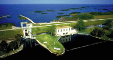
The damage caused by the 1928 hurricane convinced the Federal government to fund construction of a permanent dike around the southern perimeter of Lake Okeechobee. (Photo courtesy of: US Geological Survey)
CURWOOD: Lake Okeechobee in South Central Florida is the largest freshwater lake in the continental United States, except for Lake Michigan. Back in the 1920’s, hurricane-related flooding from the lake killed thousands of area residents. So, starting in the 1930's, the Army Corps of Engineers turned Lake Okeechobee into a reservoir half the size of Rhode Island by building Hoover Dike. The dike is as wide as a football field, three stories high, and143 miles long.
[WATERS OF DESTINY: Foot by foot…mile by mile the work went on….drilling, blasting, digging..bite by bite..5 to 8 cubic yards per mouthful…slowly persistently gauging the bottom to buildup the top.]
CURWOOD: Hoover Dike was designed to tame Mother Nature. Not only was it to contain the damage and devastation from hurricanes which regularly ravaged the region, it also helped to turn the timber marshland of central Florida into fertile soil for sugar cane.
[WATERS OF DESTINY: Water that once ran wild, water the ruined the rich terrain, water that took lives and land…put the disaster in the headlines and death upon the soil…now it just waits there, calm, peaceful, ready to do the bidding of man and his machines…]
CURWOOD: But today the huge dirt barrier is leaking, and there are fears Mother Nature could strike with a vengeance or terrorists might take advantage of the dams vulnerabilities. Sixty thousand people live around Lake Okeechobee, and federal security officials have designed an evacuation plan. But they refuse to show local residents detailed maps depicting Hoover Dike's most critical areas, saying they don't want to tip off would-be terrorists.
Brian Skoloff of the Associated Press in nearby West Palm Beach has been covering the issue. Hi, Brian.
SKOLOFF: How’re you doing, Steve.
CURWOOD: Now what exactly is the security concern here?
SKOLOFF: The Army Corps of Engineers’ simply, they’ve put together a bunch of flood maps that would show where water would flow if certain areas of the dike were breached, whether in a hurricane or for any other circumstance. And they’ve released one specific map that shows some detail of where breaches would go, how high flood water would rise and how far it would move away from the lake and down into the area towns.
The damage caused by the 1928 hurricane convinced the Federal government to fund construction of a permanent dike around the southern perimeter of Lake Okeechobee. (Photo courtesy of: US Geological Survey)
CURWOOD: Now it would seem that it would be obvious where the vulnerabilities are, both in what, the Hoover Dike and throughout the flood plain.
SKOLOFF: Sure. It is pretty obvious. I mean, you know, if you breach the dike at any point, a large enough hole in the dike obviously is going to create a hole in the shoreline and water’s going to flow out. And, you know, the hole idea that the Corps’ not releasing these maps may not be that big of a deal for the public.
The public is being made aware of evacuation plans and different things they need to do to prepare. These maps are being given to all the emergency planners in the area to use in developing their evacuation plans. So it’s not that urgent that residents need to see these maps; residents are just concerned they’re not being told everything they need to know simply because, you know, they live right up against this dike, and they see images of Katrina and New Orleans and they’re frightened.
CURWOOD: Now I understand that the Army Corps of Engineers has stopped working on the dike. Why is that?
SKOLOFF: Yeah, they’ve encountered some problems with the work that they were trying to do in a specific point. There’s a section – they’ve broken up their work into about eight sections on this 143-mile dike – this section that they’re working on now is on the south side of the lake, it’s about 26 miles long. The contractor that was working there was working to put a 36-foot-deep, two-foot-thick concrete wall straight down into the middle of the dike to create this barrier to keep water from seeping out.
What they were finding was happening, though, is the dike itself now is made up of soil dredged from the lake, shell pieces, just muck that was pounded together to create this wall. And as they’re digging this trench to put the concrete wall in, the wall is caving in on itself and filling the trench. So obviously that technique was not working, so they decided they weren’t going to waste any more time and money; they were going to halt construction and go back to the drawing board and redevelop some different plans and designs to come up with a different idea.
CURWOOD: Let me just be clear – what is the scenario then that people living around the lake should be worried about? What does the Army Corps say is the worst-case scenario for Lake Okeechobee?
SKOLOFF: Well, you know, according to their maps and their plans that they’ve put together for evacuations, one example, I guess – there’s a whole lot of different scenarios – one example is if the lake were at 21 feet and a major hurricane were to come through today, a breach could occur on the south side.
If that did occur, flooding could extend about 32 miles south and remain inundated for up to 45 days as they repair the dike. Now we’re not talking neck-deep water here; they think it would probably be maybe knee-deep that far out. But this is what they call a apocalyptic scenario, their doomsday scenario, that they’re saying would really never occur because the lake is never going to be at 21 feet.
CURWOOD: There’s a lot of hurricane history at Lake Okeechobee. Tell me about the storm of 1928.
SKOLOFF: Sure. Actually, there were two. The first one came through in 1926; that one severely devastated the area around Lake Okeechobee. Obviously, there wasn’t a dike there at the time, so it just pushed the waters over Lake Okeechobee. At that time about 4,200 people were killed, but that was throughout Florida, Mississippi and Alabama.
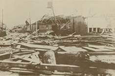
Wreckage from the hurricane of 1928, south of Lake Okeechobee (Photo Courtesy of: NOAA)
At that point the Corps got to work and started building this dike around the lake. In 1932’s when the started, 1970 they completed it.
CURWOOD: Is there anyone around who remembers the big storm of 1928?
SKOLOFF: Sure. These towns tend to keep their residents. A lot of people that live here have lived here their entire lives, there’s multiple generations. So there’s a number of people around that remember the 1928 hurricane.
One guy I spoke to named Haker Lowe, he’s in his 80s. He remembers riding out the 1928 storm on a houseboat off a tributary off Lake Okeechobee with his family, saying it was just terrifying, with the howling wind and the water and the rain pelting down. And that by the next morning, once the hurricane passed, they went to go find their house and their house was completely gone. So they basically survived by leaving their house and taking refuge on a houseboat.
The memories are still very vivid. In Belle Glade, one of the towns down there, there’s actually a statue that stands in front of the city hall. It’s a really interesting statue of a mother and a father and a young child. The mother’s clutching a baby and they’re sort of running and looking back over their heads, and there’s these waves coming at them. It’s just a plaque to commemorate the 2,500-some people that died in the area there when that storm did flood through.
CURWOOD: Brian Skoloff is the West Palm Beach correspondent for the Associated Press. Brian, thanks for speaking with me.
SKOLOFF: Thanks for having me.
Related links:
- US Army Corps, South Florida Operations Office
- South Florida Water Management District
[MUSIC: Willy Mason “Not Lie Down” from ‘Scraps’ (Astralwerks - 2006)]
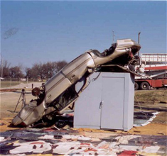
Shelter from the Storm
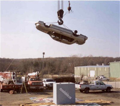
At a Tulsa Home and Garden Show Demonstration, a 1989 Lincoln Continental is suspended 40 feet above a storm-safe shelter. (Photo courtesy of: Storm Safe Rooms)
CURWOOD: Well, the tornado and hurricane season is here. It’s the busy time of year for Brad Webb. His Tulsa, Oklahoma, company, Storm Safe Rooms, produces steel-reinforced shelters from violent windstorms. Mr. Webb, hello.
WEBB: How’re you doing?
CURWOOD: Now can you just briefly describe what one of your safe rooms looks like?
WEBB: Well our best-selling safe room is a four-foot by six-foot box, basically, six-foot two-inch tall headroom, got a little folding two-person bench in the unit for people to sit on. About 90 percent of them slide into the garage and bolt down. Some of our safe rooms, of course, you can put electrical switches in ‘em and light switches and resets. You can insulate ‘em, screw sheet rock to ‘em, trim ‘em, paint ‘em, make them look like the rest of the house, and you can’t even tell it’s a Safe room.
CURWOOD: So how do you know that they’re safe, that they can survive a Category 5 hurricane or a tornado?
At a Tulsa Home and Garden Show Demonstration, a 1989 Lincoln Continental is suspended 40 feet above a storm-safe shelter. (Photo courtesy of: Storm Safe Rooms)
To give you an idea of just how tough that test is, here a few years back during the Tulsa home and garden show we dropped a 1989 Lincoln Continental 40 feet using a hundred ton crane doing a demonstration for the home and garden show.
CURWOOD: Yeah.
WEBB: We dropped it on to this safe room two times and just demolished the car, and we didn’t even make a dent in this safe room.
CURWOOD: Now, are these designed to survive floods and earthquakes as well?
Lincoln Continental and storm-safe room, post-demonstration. (Photo courtesy of: Storm Safe Rooms)
CURWOOD: I got an ethical question for you. Somebody has a Storm Safe Room, it’s got room for, let’s say, six people, and there are ten people there. Maybe the folks next door, maybe the kids from down the block are there. What are they gonna do?
WEBB: Well, five square feet per person is the standard. But I’ve heard, you know, I’ve heard stories at the home and garden shows about a tornado came through the area and we’ve got a six by eight shelter, it holds, you know, nine or 10 people, and we had 16 people in there, you know, and two dogs! So, I mean, I’m not sure if I was grandma and grandpa and the kids were all visiting and tornado’s coming through we wouldn’t, you know, leave them out in the garage.
CURWOOD: Is it a good idea to let your neighbors know that you have one of these things?
WEBB: Well, you know, most people are pretty private about ‘em, really. Sometimes when I was first starting this business I had little signs made that show my name and phone number in the front yard while we’re putting one in, and about nine out of 10 customers didn’t really want me to even display a sign. So it seems to be a pretty private thing.
CURWOOD: They don’t want the neighbors from down the street to come running up and bang on their door at the last minute, huh?
WEBB: Yeah. And some neighbors, you know, are more worried about seeing a little bit of wind and they’re calling ‘em and running over to the house. One guy might think it’s no big deal, wish they weren’t coming over every time the wind blows, you know.
CURWOOD: What do you suppose people think they’re going to do otherwise?
WEBB: I think it’s out of sight out of mind business. Until you really have one of them big F5 bad boys, or an F4, or even an F2 bear down right directly on you, I mean, it’s, it can be pretty frightening. Until then, you know, a lot of folks just think “It’s never going to happen to me.” You know, kind of like “I’m never gonna have a” – one guy explained it to me when I put a shelter in, “I hope I never have to use it, and I hope I never have a head-on collision in my car, but I’m gonna keep wearing my seatbelt.
CURWOOD: Well thank you so much, sir, for filling us in on the Storm Safe Rooms.
WEBB: You’re welcome. I appreciate it.
CURWOOD: Brad Webb is owner of Storm Safe Rooms in Tulsa, Oklahoma.
Related links:
- Storm Safe Rooms
- Texas Tech University: Wind Science and Engineering Research Center
[MUSIC: Willy Mason “Not Lie Down” from ‘Scraps’ (Astralwerks - 2006)]
CURWOOD: You can hear our program anytime on our website, or get a download for your iPod or other personal listening device. The address is LOE dot org. That's LOE dot O-R-G. You can reach us at comments @ l-o-e dot org. Once again, comments @ l-o-e dot O-R-G. Our postal address is 20 Holland Street, Somerville, Massachusetts, 02144. And you can call our listener line, at 800-218-9988. That's 800-218-99-88. CD's and transcripts are fifteen dollars.
Coming up: A river runs through it. Yes, Los Angeles has a river, and it’s cleaning up its act. Stay tuned to Living on Earth.
ANNOUNCER: Support for N-P-R comes from N-P-R stations, and: Kashi, maker of all natural foods, founded on the belief that everyone has the power to make healthful changes. Kashi. Seven whole grains on a mission; The Kresge Foundation, investing in nonprofits to help them catalyze growth, connect to stakeholders, and challenge greater support. On the web at Kresge dot org; The Annenberg Fund for excellence in communications and education; The W-K Kellogg Foundation. 'From Vision to Innovative Impact: 75 Years of Philanthropy' This is N-P-R -- National Public Radio.
[MUSIC: Not Drowning Waving “Walk” from ‘Through The One Last Door’ (Liberation - 2005)]
Emerging Science Note/Backs to the Future
CURWOOD: It’s Living on Earth. I’m Steve Curwood. Coming up: A river runs through it. Yes, Los Angeles has a river, and it’s cleaning up its act. First this note on emerging science from Tobin Hack.
[SCIENCE NOTE THEME]
HACK: Time is a slippery concept, so people use spatial metaphors in their speech and gestures to represent the movement of time. For example, we gesture forward when we talk about the future, and backward when speaking about our past – at least most people. Not the Aymara. The Aymara – an indigenous people in the Andean Highlands of Bolivia, Peru, and Chile – put their past in front of them, and their future behind.
Each of the roughly 6,000 languages spoken around the world incorporates subtle cultural differences into this spatial metaphor for time, but the Aymara diverge completely from the global norm. Ask an Aymara speaker to tell a story about his ancestors, and he’ll gesture towards the space in front of him. Ask him about his plans for tomorrow, and he’ll point behind him.
College student Raphael Nunez noticed this phenomenon while hitchhiking in the Andes over a decade ago. Intrigued, he returned, with a Ph.D. in cognitive science, to conduct formal research. Nunez found that, for the Aymara, seeing is literally believing. An Aymara speaker always qualifies even the most mundane statement by indicating what they saw or did not see.
With such great emphasis placed on vision, it’s no wonder that the Aymara locate the past in front of them; they have, literally, seen it with their own eyes. By the same token, the future is the great, mysterious expanse that will always lie behind them, unseen and unknown.
But today, while the future may still lie behind the Aymara, it’s rapidly catching up with them. Global mass communication seems to be taking a toll; young Aymara speakers are reorienting their spatial metaphor for time. Now if you ask them to talk about tomorrow, they’ll point ahead, putting their past behind them.
This latest research suggests that our spatial perception of time is relative, and not universal. It’s a function of our culture and our language. Einstein would have been pleased. That’s this week’s note on emerging science, I’m Tobin Hack.
Related link:
Guardian Unlimited article: How Time Flies
Remaking the Los Angeles River
The LA River flows through the community of Atwater Village, north of downtown Los Angeles. (Photo: Ilsa Setziol)
CURWOOD: Since the Industrial Revolution, people have counted on the rivers to be workhorses: ferrying goods, turning the mills, and absorbing pollution flushed out of factories. So, in the past, many cities turned their backs on their foul-smelling, channelized rivers.
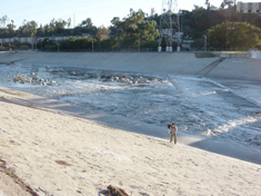
It would be a sorry contest, but perhaps nowhere has the neglect been greater than Los Angeles. Yes, there is a river in L.A., though you might mistake its often-dry, concrete-lined bed for another freeway. After decades of viewing the Los Angeles River as a flood control channel – and as a joke – Angelinos are working now to revive their river.
From member station KPCC in L.A., Ilsa Setziol tells about the ruin and possible rebirth of the Los Angeles River.
SETZIOL: Near Dodger stadium, a mostly Latino and Asian neighborhood called Elysian Valley backs up on the river. Joe Linton pushes his bike into tiny Rattlesnake Park.
[URBAN OUTDOOR SOUNDS; CARS IN BACKGROUND, BIRDS]
LINTON: So this pocket park was a dumping area, there were mattresses and trash. When the crews were clearing away the trash they actually found a family of rattlesnakes.
The LA River flows through the community of Atwater Village, north of downtown Los Angeles. (Photo: Ilsa Setziol)
LINTON: The strategy to date’s been kind of opportunistic, and so a lot of the reclaiming that’s been done has been planting these native trees, using the artwork, the river rocks, to begin to bring back a sense of a river – even though the river itself still needs a lot of work. But really the complexion of the river’s begun to change with these small interventions strung together.
[BIKING SOUND]
SETZIOL: Linton, who is with Friends of the Los Angeles River, slides onto his bike and heads downstream along the top of a levee toward downtown L.A. He passes rows of newly planted trees and nine mini-parks.
[URBAN SOUNDS, TRAFFIC, SIREN]
SETZIOL: Angelinos are starting to gather in these and other new parks, enjoying the river in places that used to be fenced off.
[DRUMMING]
SETZIOL: Downstream at a new 30-acre state park, a group of cyclists gathers at the end of an evening of performance art. Nelson Ornelas, Eric Crawford, and Philip Franco kick around ideas for the river.
ORNELAS: I seen this city live up. I seen it changing, there’s transformation. This used to be a railroad track. We used to come here and party, my gang. I love this transformation. This city’s got so much vibes and so much potential.
FRANCO: We’re in the desert. We need this water.
CRAWFORD: Could there ultimately be cafes on the L.A. River where you just have a glass of wine?
FRANCO: Maybe taco trucks certain parts of the day. (Laughter)
[CONVERSATION FADES; DRUMMING]
SETZIOL: In fact, many Angelinos now want a lot from this river: more parks, cleaner water, a fix for neglected neighborhoods, and a healthier inner city.
[RUNNING WATER, RIVER SOUNDS]
Plastic bags and other debris are a common sight along the LA River. (Photo: Ilsa Setziol)
[MOVING WATER]
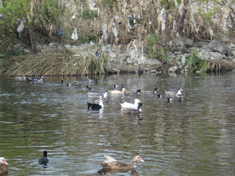
SETZIOL: The river’s tributaries rushed out of the mountains surrounding the city, including the 9,000-foot San Gabriel Mountains. At the foot of the San Gabriels, ornithologist Kimball Garrett of the L.A. County Natural History Museum surveys a reservoir behind a large dam built for flood protection. A black-crowned Night-Heron perches in a willow, motionless, waiting out the day. Ruddy ducks, cormorants and western grebes…
[GREBE CALL]
SETZIOL: …cruise through glassy water.
[GREBE CALL]
SETZIOL: Garrett says as the L.A. River flowed into the basin and out to sea, it would weave around a broad prairie, filling up low-lying areas.
GARRETT: A lot of the sort of backwater areas that did grow up to what you really could call a riparian forest or jungle – cottonwoods, willows, vines and tangles that would go on and on and on, extensive marshlands. There were species that bred there that have completely disappeared, things like the yellow-billed Cuckoo, the long-eared owl.
[MOVING WATER]
SETZIOL: The river also created habitat for arroyo toads, red-legged frogs, and other species that have disappeared from the watershed. Even large ocean-dwelling Steelhead trout were here. Born in the mountain headwaters, they grew big and sleek in the ocean and would return to spawn, some 50 miles upstream. But as Angelinos built homes, businesses and farms in the L.A. basin, people diverted water out of the river into pipes, leaving much of it dry in the summer.
Los Angeles City Councilman Ed Reyes.
REYES: The river became essentially where you hid your gas lines, your pipelines, your power lines, your rail lines, and you let those people live there. So it became a social and economic divider. They defined it as a place in which you send those other people to the other side of the tracks.
SETZIOL: In the late 1930s, Ralph Lopez Urbina lived here. He and his pals swam in the river when it was still marshy and green. They captured pigeons roosting on the bridges. URBINA: We also did a little fishing, cause there were river minnows in the water, and there were pollywogs and frogs. And then there was the red crayfish – bright, crimson, you know – we used to like to capture them and study them and play with them. I would play hooky from school and go to the L.A. River. Really, you know. Because it was a lot more interesting. (Laughs)
SETZIOL: As Los Angeles sprawled, people built right up close to the river and on land where it sometimes flooded, so that when a record flood came in 1938, it damaged $60 million dollars in property and killed 59 people.
Enter the Army Corps of Engineers, with a plan to confine the wayward current to a concrete channel. It took 25 years, but nearly all the river's 52 miles were paved. [SOUND OF DUCKS]
SETZIOL: Still, nature persisted where it could. North of downtown, there's an eight-mile stretch where there’s no concrete on the bottom. Ducks still nest here among willow trees laden with trash. Long-legged shore birds stride alongside graffiti scrawled on the concrete bank. They dip their slender bills into treated waste-water that constitutes most of the river’s flow today. In the 1980s, a group of artists – like the taggers – saw all that concrete as a blank canvas, a place for a different vision. Poet Lewis McAdams and others founded Friends of the Los Angeles River.
McADAMS: The basic line was meeting people down by the river, and making the river a place where people gather in the central city, in the place where the city – the reason the city is here is because of the Los Angeles River. SETZIOL: They dreamt of a real river. Bureaucrats initially dismissed the idea as quixotic. But after a decade of legal and public relations efforts, their attitudes began to change. Los Angeles is now developing a new river master plan.
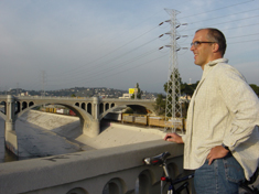
Joe Linton, of Friends of the Los Angeles River, looks at a stretch of the river channel in downtown LA, and one of its historic bridges. (Photo: Ilsa Setziol)
SETZIOL: Atop a levee, Joe Linton continues his ride. His dream is of jackhammers. He says they'd go a long way. LINTON: Full-scale restoration’s probably not possible. The river used to wander around, and we’ve pretty much developed it. But the truth is a lot of stretches that don’t have any real riparian habitat, that don’t have places where the water touches the earth, could be restructured and rebuilt, terraced, reconfigured. They won’t be fully natural – there will be some sort of reinforcement – but they won’t be just water running over concrete anymore. SETZIOL: But Angelinos aren’t likely to see large-scale removal of concrete in the near future. Engineers say the smooth and barren channel speeds storm water out to the ocean, so it doesn't flood. Colonel Alex Dornstauder of the U.S. Army Corp of Engineers says the channel needs to stay robust.
DORNSTAUDER: At storm level, we’re passing approximately the same amount of water as comes down the Colorado River. The elevation change from the mountains to the ocean is about the same as you’d find in the entire course of the Mississippi River. SETZIOL: That speed presents a challenge for greening the river. Fast flows will just rip out new vegetation. There’s more green on Dornstauder’s fatigues than in channel near where we're standing. He says more vegetation in the channel would slow down the water, increasing the flood risk. DORNSTAUDER: If we’re going to change the dynamics of the channel, if we’re going to not allow the velocity to flow specifically along the concrete, we’re going to have to increase the area. Or if we’re going to roughen up the surface with vegetation, it’s going to have to increase the area. SETZIOL: One solution, then, is giving the river more room. That’s possible in some places. Los Angeles plans to focus on five areas where there’s enough open space to widen the channel or make new parks.
[RIVER SOUNDS, RUNNING WATER]
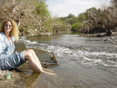
Melanie Winter, of The River Project, dips her toes into the River in one of the few places where there is no concrete on the bottom. (Photo: Ilsa Setziol)
WINTER: Which it never was tasked with doing before. The ground, the dirt throughout took its share, and it’s no longer allowed to. By ordinance, every drop is supposed to fall into a concrete gutter, and hence a storm drain, and hence the Los Angeles River. SETZIOL: Melanie Winter dips her toes into the river at Sepulveda basin, a flood control area in the San Fernando Valley. With no concrete on the bottom here, the water licks at the bare earth. It swerves around willow trees, tugs at plastic bags, races through the grates of abandoned shopping carts. Winter says despite the obstacles, a major restoration is possible.
WINTER: If enough people agree and find it to be a priority for them, it’s absolutely possible.
[SOUND OF KING FISHER]
SETZIOL: A king fisher! WINTER: (blasé) Yeah, they’re here all the time.
[WING FLAPPING SOUND]
WINTER: The only reason other people haven’t made it a priority is they haven’t come down here and been surprised by a kingfisher and realized that that’s in their own backyard. SETZIOL: Winter says to ease the burden on the L.A. River, Los Angeles needs to allow more rainwater to filter into the ground instead of washing onto streets. Not just because storm water flow is so heavy, but because it gets nastier the farther it flows.
[SOUND OF FREEWAY]
NAHAI: It’s dirty because storm drains empty out into the LA River without any treatment whatsoever.
David Nahai, Chair of the Los Angeles Regional Water Quality Control Board, leads the charge to clean up the river. (Photo: Ilsa Setziol)
NAHAI: What is left on our streets goes into the storm drains, into our waterways and out to the ocean. It’s a very stark equation: pet feces; oftentimes human fecal material; to oil, grease, fertilizers, pesticides, and of course, the ubiquitous litter. SETZIOL: Nahai glares at the food wrappers and soda cans littering a levee. Every year, he says, the county hauls out enough trash to fill about 200 dump trucks.
[FREEWAY SOUNDS AND FINCH BIRDSONG]
SETZIOL: To clean up the river, the water board is setting regulations on dozens of contaminants, using a previously ignored section of the federal Clean Water Act. But there’s debate over the goal. Should a river that’s become a storm drain be held to a fishing and swimming standard? The water board says yes. But some say, why? People aren’t allowed to swim in the river anymore.
Larry Forester is vice mayor of Signal Hill. FORESTER: We prohibit entry into the river right now. I don’t think that should change. Now do I think some of the side areas could be used to develop parks, as long as we keep people out of the water? Yes.
SETZIOL: And then there are the freeways. Much of the Los Angeles River is shadowed by four of them. But to L.A. City Councilman Ed Reyes, the urban blight surrounding the river is all the more reason to transform it. REYES: This happens to be where working folks live, people of color live. We have to go to the places that has the greatest effect, that has the greatest potential to cause relief, to create healing. And I think you need to go into the areas that’s the most severe.
SETZIOL: The years of neglect – and fencing installed to keep people out – have made the Los Angeles River a good hideout for the homeless and for youth, some in and some out of trouble. CARR: This is a kind of no-man’s land down here.
SETZIOL: Netti Carr of Friends of Atwater Village walks a stretch of the River in the Latino community of south Atwater.
CARR: The LAPD, they only down here if there’s something really wrong. The homeless know it’s a very safe place for them, so they tend to congregate down here. And the gangs do, too, because they also have a safe haven. They jump over this fence and nobody can get to them, you know?
SETZIOL: Netti Carr wants to help kids stay out of trouble by making them guardians of their river. CARR: In Atwater, in central, south Atwater, we have no amenities for the youth. We don’t have a playground, we don’t have a basketball court, we don’t have anything.
[BIKE COASTING]
LINTON: It can be a real corridor through LA that’s really about pedestrians and bicycling and not about driving. SETZIOL: Continuing his ride, Joe Linton of Friends of the L.A. River scoots off his bike at another tiny park.
LINTON: This is called Steelhead Park. You can see on the fences there’s sort of a motif of a steelhead trout. Up until the 40s the river was home to steelhead. We’ll know our job is done when the steelhead return to the river.
SETZIOL: Joe Linton also stops at a confluence of a tributary. But what’s really noticeable is the confluence of the 5 & 110 freeways.
[TRAFFIC SOUNDS]
LINTON: (talking over very loud freeway noise) This is where the Spanish explorers first encountered the L.A. River, or at least first wrote about it. They found large oaks and willows and sycamores, wild roses. They described it as a lush and pleasant spot in every aspect. [MIX OF BIKING, TRAIN, AND WATER SOUNDS]
SETZIOL: Linton heads back upriver. The sun rides low, suffusing the sky with a pink glow. The Union Pacific chugs by, evening commuters whisk by, their lights flashing. Down by the river, ducks settle in for the night. Linton sees the still silhouette of a heron reflected in the flowing water. And he rides, through the slim shadows of the young sycamores atop the concrete bank. [RIVER SOUND, BIRD CALL]
SETZIOL: For Living on Earth, I’m Ilsa Setziol.
Related links:
- Friends of the Los Angeles River
- Los Angeles Regional Water Quality Control Board
- Friends of Atwater Village
[MUSIC: Regina Spektor “Field Below” from ‘Begin To Hope’ (Sire/Warner - 2006)]
CURWOOD: Living on Earth is produced by the World Media Foundation. Our crew includes Ashley Ahearn, Chris Ballman, Eileen Bolinsky, Jennifer Chu, Bruce Gellerman, Ingrid Lobet and Jeff Young - with help from Christopher Bolick, Kelley Cronin, and James Curwood. Our interns are Bobby Bascomb and Tobin Hack. Our technical director is Dennis Foley. Alison Lirish Dean composed our themes. You can find us at LOE dot org. I’m Steve Curwood. Thanks for listening.
ANNOUNCER: Funding for Living on Earth comes from the National Science Foundation, supporting coverage of emerging science; Kashi, whose Day of Change tour features yoga lessons, natural food cooking demos and an array of Kashi products. Details at Kashi.com; Stonyfield Farm. Organic yogurt and smoothies. Stonyfield pays its farmers not to use artificial growth hormones on their cows. Details at Stonyfield dot com. Support also comes from NPR member stations, the Ford Foundation, the Town Creek Foundation, and the Saunders Hotel Group of Boston's Lennox and Copley Square Hotels. Serving you and the environment while helping preserve the past and protect the future, 800-225-7676.
ANNOUNCER2: This is NPR, National Public Radio.
Living on Earth wants to hear from you!
Living on Earth
62 Calef Highway, Suite 212
Lee, NH 03861
Telephone: 617-287-4121
E-mail: comments@loe.org
Newsletter [Click here]
Donate to Living on Earth!
Living on Earth is an independent media program and relies entirely on contributions from listeners and institutions supporting public service. Please donate now to preserve an independent environmental voice.
NewsletterLiving on Earth offers a weekly delivery of the show's rundown to your mailbox. Sign up for our newsletter today!
![]() Sailors For The Sea: Be the change you want to sea.
Sailors For The Sea: Be the change you want to sea.
 The Grantham Foundation for the Protection of the Environment: Committed to protecting and improving the health of the global environment.
 Contribute to Living on Earth and receive, as our gift to you, an archival print of one of Mark Seth Lender's extraordinary wildlife photographs. Follow the link to see Mark's current collection of photographs.
 Buy a signed copy of Mark Seth Lender's book Smeagull the Seagull & support Living on Earth
© Copyright World Media Foundation. All Rights Reserved
Home | Contact | RSS | Donate | Newsletter