Hug-a-Map Week
Air Date: Week of November 14, 2008
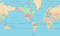
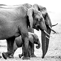
In this Mercator projection of the world Greenland appears much larger than Australia because it is near the edge of the map. In reality Greenland is 3.5 times smaller than the land down under. (Courtesy of worldatlas.us)
Africa’s southern Sahara is getting greener and the Arctic is melting. These are just two geographic changes depicted in Oxford's latest edition of the Atlas of the World. Host Bruce Gellerman talks with Atlas editor Ben Keene in celebration of Geography Awareness Week.
Transcript
GELLERMAN: All right, class, as you know, Geography Awareness Week begins November 16th - so sit up straight, eyes on your own paper. To commemorate the week we’re going to have the Living on Earth snap geo-quiz. Question 1: What’s the most densely populated country in the world? A) Bangladesh. B) Barbados C) Monaco. Question 2: Fill in the blank: What religion in the world has the most followers? We’ll give you the answers, but first let’s talk geography with Ben Keene. He’s editor of the Oxford Atlas of the World. Its latest edition is now out, and Mr. Keene, welcome to Living on Earth.
KEENE: Thanks very much.
GELLERMAN: Boy, this is a big beautiful book. It’s got tons of pictures and the index alone I was counting has a hundred and ten pages. It weighs eight pounds.

Oxford Atlas of the World
KEENE: We didn’t want to really skimp on anything, so we tried to really cram it full of information and maps, and hopefully we achieved that.
GELLERMAN: But you know in a world of Google earth and GPS devices, why on earth do we need an atlas, a paper atlas?
KEENE: An atlas gives you a perspective that you don’t necessarily get online and looking at maps and Google earth. What I like about atlases is that it really is a great way to show you the relationships between things in space. I think there’s something really lovely about letting your mind wander, letting your eye wander. It sort of sparks imagination in a way.
GELLERMAN: Mr. Keene, what’s the biggest change in this year's edition of the Oxford Atlas?
KEENE: That’s kind of a tough question. If you open our Oxford Atlas of the World the first couple of pages we show maps of the poles that show the extent of summer sea ice has actually been shrinking. That is something that you can see quite clearly in our atlas, so that actually scientists are predicting that the Northwest Passage will actually be a reality. One would be able to sail from, you know, Baffin Bay in Greenland over to the Bering Sea and Russia.
Ben Keene
KEENE: Mm-hmm. Scientists who are working in the Sahel region, which is just the southern edge of the Sahara noticed in a map-able way that vegetation was returning to that part of the world, better land management and just sort of the relocation of people, movement of settlements in that area has changed the geography there.
GELLERMAN: Every map basically has built in lies, you know what I mean? I’m looking at the – Mercator projection - of the world, and Greenland is humongous compared to even Australia – looks bigger. And it's not.
KEENE: Uh-huh.
GELLERMAN: It’s a lot smaller.
In this Mercator projection of the world Greenland appears much larger than Australia because it is near the edge of the map. In reality Greenland is 3.5 times smaller than the land down under. (Courtesy of worldatlas.us)
KEENE: Yeah. I mean, you’re right. Every map does lie. I don’t like to say that publicly…
GELLERMAN: [laughing]
KEENE: … but you’ve caught me. [Laughs] But it’s sort of a lie of necessity. The challenge that mapmakers face is to depict on a flat page or a flat surface something that isn’t flat. So, no matter what type of map projection you use, there’s always going to be some distortion. As you pointed out, the Mercator projection is not particularly successful at keeping the areas of landmasses accurate, especially at the poles – so therefore Greenland looks much larger than it is. But what it is successful at doing is accurately showing the shapes of continents and landmasses. So you try to find a balance between those things, so that the shape and the area are as close to reality as possible.
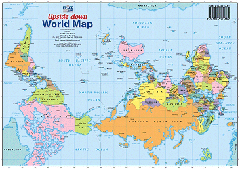
This map showing Australia and South America at the top is just as valid as conventional maps showing them at the bottom of the page.
GELLERMAN: Well, you know, Mr. Keene, Americans are said to be geographically challenged.
KEENE: I think that people in the United States, because we live in a rather large country, we, you know, have two neighbors, Canada and Mexico, and I’m just speculating here, but I think that, in a way, sort of serves to put blinders on us geographically speaking. So that, if you are living in a country that is surrounded by many others, you might just naturally acquire more of a familiarity with those places that immediately surround you in a way that perhaps Americans do not.
GELLERMAN: You’re being very generous, you know that, Mr. Keene.
[LAUGHING]
KEENE: I’m trying to be nice about it, yes. But there was a study that the National Geographic Society did – they were asking questions of people between the ages of 18 and 25 and the respondents from the United States were scoring absolutely at the bottom, so we could probably stand to spend more time with our atlases than we do.
GELLERMAN: Well Mr. Keene, I want to thank you very much.
KEENE: Thank you, Bruce, and I hope that everybody takes the time to go out and look at a map during Geography Awareness Week.
GELLERMAN: Ben Keene is the editor of the new edition of the Oxford Atlas of the World. And here are the answers to our quiz. The most densely populated country in the world? That would be C) Monaco. It has more than 80,000 people per square mile - four-and-a-half times more than the runner-up, Singapore. Question 2: What is the most practiced world religion? That’s Christianity, with more than two billion followers. Happy Geography Awareness Week!
Links
Living on Earth wants to hear from you!
Living on Earth
62 Calef Highway, Suite 212
Lee, NH 03861
Telephone: 617-287-4121
E-mail: comments@loe.org
Newsletter [Click here]
Donate to Living on Earth!
Living on Earth is an independent media program and relies entirely on contributions from listeners and institutions supporting public service. Please donate now to preserve an independent environmental voice.
NewsletterLiving on Earth offers a weekly delivery of the show's rundown to your mailbox. Sign up for our newsletter today!
![]() Sailors For The Sea: Be the change you want to sea.
Sailors For The Sea: Be the change you want to sea.
 The Grantham Foundation for the Protection of the Environment: Committed to protecting and improving the health of the global environment.
 Contribute to Living on Earth and receive, as our gift to you, an archival print of one of Mark Seth Lender's extraordinary wildlife photographs. Follow the link to see Mark's current collection of photographs.
 Buy a signed copy of Mark Seth Lender's book Smeagull the Seagull & support Living on Earth
© Copyright World Media Foundation. All Rights Reserved
Home | Contact | RSS | Donate | Newsletter