Extreme Weather
Air Date: Week of June 20, 2008
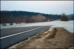
The Gasconade River pours over a highway near Mt. Sterling, Missouri in March. (Photo: Drew Backues)
Flooding in the Midwest has some wondering if extreme weather is a fluke or an indicator of a changing climate. Host Bruce Gellerman talks to Richard Heim, chief of the Climate Monitoring Branch of the National Oceanic and Atmospheric Administration, about extreme weather events in U.S. history, and predictions for the future.
Transcript
GELLERMAN: From the Jennifer and Ted Stanley Studios in Somerville, Massachusetts - this is Living on Earth. I’m Bruce Gellerman, in for Steve Curwood.
The pictures from the Midwest are devastating and eerie. There haven’t been floods like this in the region in 500 years. So is this an extreme disaster of historic proportion or something worse: an ominous sign of what’s in store for us as climate change heats up the planet? One place to look for answers is the U.S Climate Extremes Index. It measures six indicators of extreme weather going back to 1910. The National Climate Data Center compiles the Extremes Index. Richard Heim is Acting Chief of the Climate Monitoring Branch, which is in charge of the Index. Mr. Heim, welcome to Living on Earth!
HEIM: Thank you Bruce, I’m glad to be here.
GELLERMAN: So you measure extreme conditions. What’s an extreme condition?
HEIM: The way we define extreme conditions for the Climate Extremes Index is the value has to be in what’s called the top ten percentile or the bottom ten percentile. The bottom ten percentile would be the hundred coldest or driest; the top ten percentile would be the hundred warmest or wettest. And you basically categorize each observation into its percentile based upon the historical record.
GELLERMAN: So are you seeing an increase or a decrease in the Climate Extremes Index?
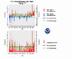
Extreme low temperatures (in blue) have disappeared while extreme high temperatures (red) are more frequent. (Courtesy of the U.S. Climate Extremes Index)
HEIM: We’re seeing an increase in the Climate Extremes Index in some of its components. The Climate Extremes Index itself, where all six are involved, shows a marked increase over the last couple decades if you look at the aggregate of all of the years combined together. But there are individual years earlier in the century that are just as extreme but they haven’t been as frequent as they are happening now in terms of the overall Index.
GELLERMAN: So which parts of the Index, which of these six indicators, are we finding more extreme now?
HEIM: There are three parts that are really more extreme in the last couple decades. They are the daily high temperatures, the daily low temperatures, and the extreme one-day precipitation events—the really heavy one-day rainfalls. The daily high temperatures have been happening more frequently in the high percentiles. In other words, we’ve been having really hot high temperatures more often in the last ten years and twenty years than we have earlier in the record. And the low temperatures have been on the warm side more often in the last twenty years than they have in the past. The number of really cold low temperatures and cold high temperatures has almost really disappeared in the last couple decades. And the number of extreme wet days, the extreme one-day precipitation events, has increased pretty strongly over the last couple decades. The last three or four years have seen spikes in that part of the index and also about three or four years in the 1990s—the 1993 floods for example show up in that particular component of the Index as well.
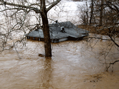
Flood water almost up to the roof line in Jefferson County, Missouri, in March. (Photo: Kristin Badolato)
GELLERMAN: Would we expect that if this was caused by global warming that that would cause more rain?
HEIM: Some of the global climate models that have been run for global warming simulations indicate that we should expect to see an increase in the frequency of really heavy rain events like these one-day extreme events and also the frequency of warm temperatures should be increasing and the frequency of cold temperatures should be decreasing. And these three components are reflecting that very, very well.
GELLERMAN: So the downpour in Iowa—can we attribute that to global warming?
HEIM: That’s a very good question and the answer is kind of, well…you can’t attribute any one event to global warming, like the downpours in a particular month or a particular year. Global warming will cause an increase in the frequency of these things. So when you look at the frequency over several years and you see it happening more and more often then you can have a greater confidence that that’s probably due to global warming.
GELLERMAN: Could there be other factors here, say La Niña or El Niño or you know, the weather just being…the weather?
The Gasconade River pours over a highway near Mt. Sterling, Missouri in March. (Photo: Drew Backues)
HEIM: Exactly. That’s what makes it so difficult to attribute any particular climate extreme or weather extreme to a particular cause because there are a variety of causes: the amount of energy coming from the sun, the circulation of the ocean currents, the circulation of the earth’s atmosphere—the jet stream and so forth. All of these things you have to kind of combine together and distill them down and determine which one is the dominant influence in a particular month. Right now, we’re at the waning end of a La Niña and we’re entering into what’s kind of called a “Neutral ENSO State” for the tropical Pacific so the other things that are influencing our weather are kind of rearing their heads now.
GELLERMAN: Can we use the Climate Extremes Index to predict conditions?
HEIM: No. The Climate Extremes Index is devised to put current anomalies into historical perspective—to show what’s happening now and what has happened in the past, to show us trends, how it compares historically. It is not a predictive tool.
GELLERMAN: So the trend is hotter and wetter and is that what we’re looking forward to in the future?
HEIM: According to the global climate models, that is what we can expect more of in the future, yes.
GELLERMAN: Well Mr. Heim, I want to thank you very much. I appreciate it.
HEIM: Thank you very much Bruce.
GELLERMAN: Richard Heim is the Acting Chief of the Climate Monitoring Branch of the National Oceanic and Atmospheric Administration.
Links
Living on Earth wants to hear from you!
Living on Earth
62 Calef Highway, Suite 212
Lee, NH 03861
Telephone: 617-287-4121
E-mail: comments@loe.org
Newsletter [Click here]
Donate to Living on Earth!
Living on Earth is an independent media program and relies entirely on contributions from listeners and institutions supporting public service. Please donate now to preserve an independent environmental voice.
NewsletterLiving on Earth offers a weekly delivery of the show's rundown to your mailbox. Sign up for our newsletter today!
![]() Sailors For The Sea: Be the change you want to sea.
Sailors For The Sea: Be the change you want to sea.
 The Grantham Foundation for the Protection of the Environment: Committed to protecting and improving the health of the global environment.
 Contribute to Living on Earth and receive, as our gift to you, an archival print of one of Mark Seth Lender's extraordinary wildlife photographs. Follow the link to see Mark's current collection of photographs.
 Buy a signed copy of Mark Seth Lender's book Smeagull the Seagull & support Living on Earth
© Copyright World Media Foundation. All Rights Reserved
Home | Contact | RSS | Donate | Newsletter